

 LPI NSW Topographic 1-25,000 Scale Maps
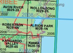
Wollongong 9029-2S NSW Topographic Map – Printed
$16.70 Inc. GST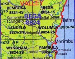 LPI NSW Topographic 1-25,000 Scale Maps
Wolumla 8824-2N NSW Topographic Map – Printed
$16.70 Inc. GST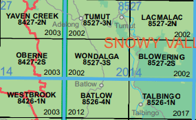 LPI NSW Topographic 1-25,000 Scale Maps
Wondalga 8527-3-S NSW Topographic Map – Printed
$16.70 Inc. GST
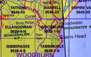 LPI NSW Topographic 1-25,000 Scale Maps
Woodburn 9539-1N NSW Topographic Map – Printed
$16.70 Inc. GST
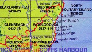 LPI NSW Topographic 1-25,000 Scale Maps
Woolgoolga 9537-4N NSW Topographic Map – Printed
$16.70 Inc. GST LPI NSW Topographic 1-25,000 Scale Maps
Woolomin 9135-3-N NSW Topographic Map – Printed
$16.70 Inc. GST

 LPI NSW Topographic 1-25,000 Scale Maps
Wootton 9333-2-N NSW Topographic Map – Printed
$16.70 Inc. GST LPI NSW Topographic 1-25,000 Scale Maps
Wullwye 9131-2-N NSW Topographic Map – Printed
$16.70 Inc. GST LPI NSW Topographic 1-25,000 Scale Maps
Wylie Creek 9340-4-N NSW Topographic Map – Printed
$16.70 Inc. GST LPI NSW Topographic 1-25,000 Scale Maps
Wyndham 8824-3S NSW Topographic Map – Printed
$16.70 Inc. GST
 LPI NSW Topographic 1-25,000 Scale Maps
Yalwal 8928-2-S NSW Topographic Map – Printed
$16.70 Inc. GST


